


Select the links below for information on the geography of Parthia:
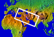 The core land areas of ancient Parthia lay between the Caspian Sea and the Persian Gulf, and its boundaries included all of modern Iran and contained portions of what are now modern Iraq, Turkey, Armenia, Azarbaijan, Turkmenistan, Afghanistan and Pakistan. These borders moved fluidly during the reign of the Arsacids, and areas to the west as far as Gaza and Palestine at one time fell under Parthian rule.
There are four basic land regions in Iran:
• The mountains - cover almost one-fourth of Iran, and most of the people in Iran live in the mountain area. The valleys among the mountains are the main area of agriculture production
• The desert
• The Caspian Sea coast - extends in a narrow strip between Alborz mountains and the sea. Almost all of Iran's forests are located there. It is the only region in Iran with heavy rainfall
• The Khuzestan plain
The area covered by ancient Parthia, which roughly corresponds to modern Iran, was approximately 648,000 square miles, about equal to the areas of Great Britain, France, Germany and Spain together, or about the size of the portion of the United States of America which lies east of Mississippi River excluding New England.
This page last updated 23 Feb 2021

|
|
|